Protecting Sydney's Future Transport Corridors
Protection of transport infrastructure will help to avoid cost overruns, delays and community disruption in the future
Transport for NSW gazetted State Environmental Planning Policy for Major Infrastructure Corridors 2020 on 3 July 2020, ushering in a new era of long-term planning and protection for infrastructure in NSW.
Our role
We’ve been supporting Transport for NSW since 2014 on the identification and protection of corridors for the North South Rail Line and South West Rail Link Extension. Based on our long-term work on these projects, this article provides insight and analysis of the new SEPP.
The SEPP aims to identify land that is intended to be used as a future infrastructure corridor (for example as a new railway line or motorway) and protects the land from development that might adversely affect the delivery of this infrastructure. The SEPP achieves this aim through two mechanisms.
Mechanism one
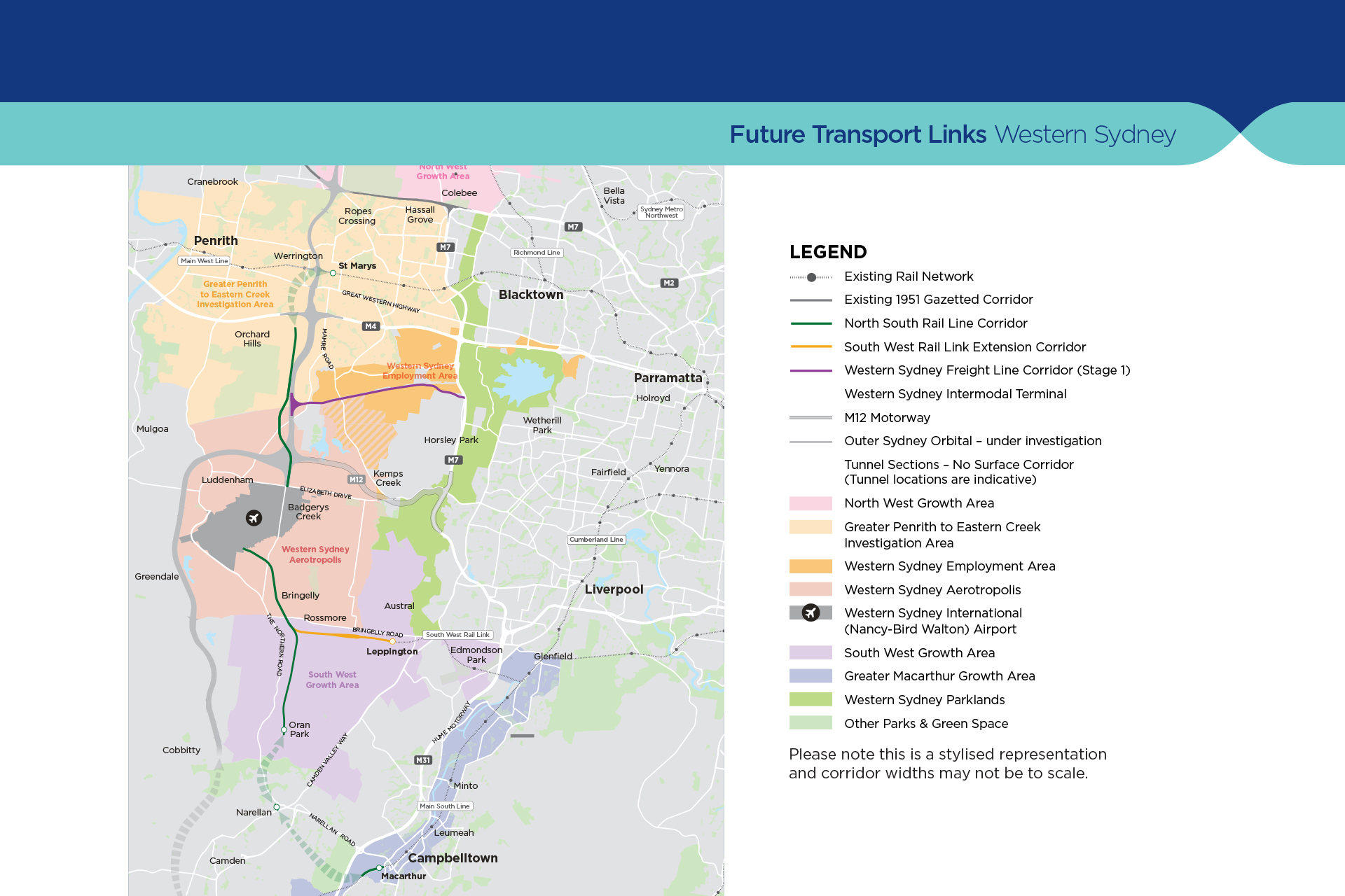
Firstly, the SEPP includes maps that identify the exact location of the future infrastructure corridors. At this stage, the SEPP has a single set of maps that essentially show three future infrastructure corridors:
- A corridor that is intended to be used for a future freight railway line between Wallgrove Road at Horsley Park, and Orchard Hills, generally following the existing Warragamba-Prospect Water Supply Pipeline – known as the Western Sydney Freight Line. Note that Transport for NSW has already identified a site along this corridor in Kemps Creek for a future intermodal terminal, that will enable freight to be efficiently moved between the rail and road networks.
- A corridor that is intended to be used for a future passenger railway line between St Marys and Macarthur, via the Western Sydney Airport and Aerotropolis at Badgerys Creek, Oran Park and Narellan – known as the North South Rail Line. The first stage of this corridor is already subject of detailed planning assessment to provide for the Sydney Metro Western Sydney Airport, which is intended to be operational at the same time as the Western Sydney Airport in 2026. A Scoping Report for Stage 1 of this project is available here.
- A corridor that is intended to be used for extension of the existing passenger railway line at Leppington to the Western Sydney Aerotropolis at Badgerys Creek – known as the South West Rail Link Extension.
Mechanism two
Re-zone the mapped corridors as SP2 Infrastructure, however it includes a special allowance for the continuation of existing development that was carried out before the land was zoned for infrastructure.
- Prohibit subdivision within the corridor (except for a boundary realignment that does not create an additional lot within the corridor).
- Require the referral to Transport for NSW of development applications on land within the corridor where the development has a capital investment value of over $200,000. These developments cannot proceed without the concurrence of Transport for NSW, who will consider the timing and likely additional cost of constructing infrastructure in the future as a result of the proposed development.
- Require the referral to Transport for NSW of development applications that involve excavation within the corridor or within 25 metres of the corridor. Excavations cannot proceed without the concurrence of Transport for NSW, who will consider the effects of the development on safety, structural integrity and effective operation of future infrastructure.
The SEPP also nominates Transport for NSW as the acquiring authority for any land within the corridor that is acquired in the future for transport infrastructure.
Landowners and stakeholders
Transport for NSW has prepared a website with information for landowners, planners and other stakeholders and interested parties, which includes links to maps and strategic environmental assessments of the protected corridors as well as submissions reports and frequently asked questions.
Future rail connections
Consistent with Transport for NSW’s strategy document Future Transport 2056, the Department has already undertaken investigations for the Outer Sydney Orbital, between Box Hill in the north and the Hume Motorway near Menangle in the south (with potential future connections towards the Illawarra and the Central Coast) and has identified future rail connections extending the North South Rail Line towards Rouse Hill, and a new rail link connecting Western Sydney Airport directly to Parramatta.
A prosperous tomorrow
As identified by Infrastructure Australia, protection of vital infrastructure corridors will help to avoid cost overruns, delays and community disruption when delivering new infrastructure in the future. With the important first step of protecting these first three infrastructure corridors mapped in the new SEPP achieved, and a long-term plan for investigating additional infrastructure corridors that may require protection, NSW has now embedded strategic long-term infrastructure planning into the land use planning framework. This effectively integrates long term land use and transport planning in a way that will contribute to Sydney’s future prosperity.
For more information, please get in touch with our planning expert Tim Ward.
Related Insights
How Immigration Shapes Housing Choices in Victoria?
NSW Low and Mid-Rise Housing Reforms
NSW Government Releases Industrial Lands Action Plan


